Home 
Products
Services
Technology Library
About Us
Careers 
GeoCockpit™ 
Contact
 
    Hardware
    Hardware
    Hardware
    Software
    Software
    Software
    Customized Geophysical Systems    
    Customized Geophysical Systems    
    Customized Geophysical Systems    
 
    Acquisition Transmitter & Receiver Controller
    Acquisition Transmitter & Receiver Controller
    Acquisition Transmitter & Receiver Controller
    Data Aquisition Unit
    Data Aquisition Unit
    Data Aquisition Unit
    Data Acquisition Station
    Data Acquisition Station
    Data Acquisition Station
    Land Magnetometer
    Land Magnetometer
    Land Magnetometer
    Marine Magnetometer
    Marine Magnetometer
    Marine Magnetometer
    MR-ML™
    MR-ML™
    MR-ML™
    LEMI
    LEMI
    LEMI
    CSEM Transmitter
    CSEM Transmitter
    CSEM Transmitter
 
    Hole-o-Grav
    Hole-o-Grav
    Hole-o-Grav
    IX1D-Marine
    IX1D-Marine
    IX1D-Marine
    Lotem-Suite
    Lotem-Suite
    Lotem-Suite
    Spectral Power
    Spectral Power
    Spectral Power
 
    Marine and Land Controlled Source ElectroMagnetics (CSEM)
    Marine and Land Controlled Source ElectroMagnetics (CSEM)
    Marine and Land Controlled Source ElectroMagnetics (CSEM)
    Borehole System Development
    Borehole System Development
    Borehole System Development
    Permanent Sensor Technology Development
    Permanent Sensor Technology Development
    Permanent Sensor Technology Development
    KMS Array System
    KMS Array System
    KMS Array System
    MT Survey System
    MT Survey System
    MT Survey System
 
    Land MT, MT/gravity, CSEM (Lotem acquisition)
    Land MT, MT/gravity, CSEM (Lotem acquisition)
    Land MT, MT/gravity, CSEM (Lotem acquisition)
    Land EM survey feasibility study
    Land EM survey feasibility study
    Land EM survey feasibility study
    Integration of EM and seismic
    Integration of EM and seismic
    Integration of EM and seismic
    3D ElectroMagnetic (EM) modeling and inversion
    3D ElectroMagnetic (EM) modeling and inversion
    3D ElectroMagnetic (EM) modeling and inversion
    Geophysical advisory
    Geophysical advisory
    Geophysical advisory
    Technology evaluation/development
    Technology evaluation/development
    Technology evaluation/development
    EM support for oil companies
    EM support for oil companies
    EM support for oil companies
    Technical training courses
    Technical training courses
    Technical training courses
 
    Publications
    Publications
    Publications
    Presentations
    Presentations
    Presentations
    Software
    Software
    Software
    Shareware, etc.
    Shareware, etc.
    Shareware, etc.
    Patents & Trademarks
    Patents & Trademarks
    Patents & Trademarks
    KMS Flyers
    KMS Flyers
    KMS Flyers
 
    KMS company overview
    KMS company overview
    KMS company overview
    LEMI
    LEMI
    LEMI
    Consultants
    Consultants
    Consultants
    Clients/collaborators
    Clients/collaborators
    Clients/collaborators
    Honors and kudos
    Honors and kudos
    Honors and kudos
    News
    News
    News
    Press releases
    Press releases
    Press releases
    Community service
    Community service
    Community service
 
    Our coordinates
    Our coordinates
    Our coordinates
    Send e-mail
    Send e-mail
    Send e-mail
    Internet feedback
    Internet feedback
    Internet feedback
 

Downloads

Lotem-Suite flyer [435 KB]

LotemSuiteSetup.exe [2.17 MB]

CSEM (Lotem)

1-Dimensional forward modeling software for CSEM

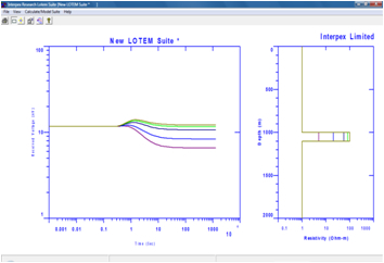
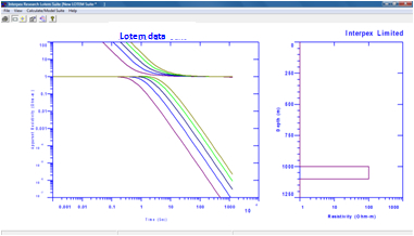
Lotem-Suite is a software package developed to perform 1-dimensional (1D) Controlled Source ElectroMagnetics (CSEM) modeling. LOTEM is a Time Domain Electromagnetic method (TEM) which uses grounded electric dipole sources for detection and delineation of resistive features in the subsurface.

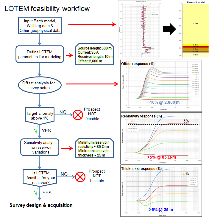
The LOTEM method can also be used for:

  • Mapping thin resistive layers, e.g. hydrocarbon saturated layers
  • Determining conductive structures, e.g. geothermal anomalies
  • Sub-basalt and sub-salt imaging
  • Complete scanning of the subsurface from shallow to deep structures

Features of LOTEM-Suite include:

  • Multi-component calculations
  • Multiple parameter variations for single layers
  • Spreadsheet data editors with Copy & Paste
  • Spreadsheet model editors
  • Multiple display features
  • ASCII File Export of data  & models

Licensing and Distribution

LotemSuite is distributed as copy-protected software. The software can be downloaded and it works fully during the 30-day evaluation period. After the evaluation you are required to purchase the package in order to continue using it. Purchase price is $999.00 plus shipping. License is offered with your choice of USB or Parallel key.

Licensed Versions

Licensed users can obtain e-mail support by sending requests for assistance, bug fixes and feature enhancements to info@interpex.com Please include the serial number, version number and attach the files with which you are having problems to your e-mail request.

The newest version can be downloaded from this website and will work with your licensed hardware key.

Ordering

Option 1: Please print out the order form included with the install and FAX to +1 303 278 4007 or use your own purchase order form to furnish credit card, billing and shipping address information, amount and cardholder name with signature.

Option 2: Use the following link to fill out an order form online.