Hole-o-Grav
Interpreting borehole gravity data
Hole-o-Grav is a premier software package funded and guided by KMS Technologies for interpreting borehole gravity data, and is distributed and supported by HarbourDom GmbH and Interpex Ltd. If you are interested on this software package you may fill out our order form.
Hole-o-Grav is a new program for the interpretation of gravity data. Like other programs it can be used for surface data but it also has special features for the interpretation of borehole gravity data. Hole-o-Grav can handle an unlimited number of boreholes in one model. For each well the coordinates and the elevation are required.
Hole-o-Grav can handle the following input data:
-
Gravity data with corrections applied (i.e. instrument drift, tidal, "free air", topography)
-
Vertical depth of the gravity stations
-
Logged depth (along the measuring cable)
-
Horizontal coordinates of each station in relation to the well position
-
Density log
Data can be imported from ASCII files or edited manually.
From the input data Hole-o-Grav can calculate
-
Apparent density
-
Borehole Bouguer Anomaly
-
Density profile averaged over the station intervals of the borehole gravity meter
-
Automatic separation of the gravity into two parts, representing the influence of 1-D ("layered earth") and 3-D structures
The model gravity data are processed in the same way as the observed data so that a direct comparison between them is possible and the model fit can be checked easily.
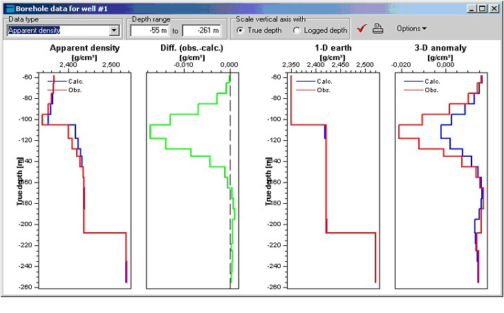
Figure1: Hole-o-Grav software registration Figure 2: Model built with Hole-o-Grav software.
window.